
Seixal topographic map
Interactive map
Click on the map to display elevation.
About this map
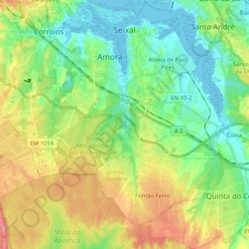
Name: Seixal topographic map, elevation, terrain.
Location: Seixal, Setúbal, Portugal (38.54068 -9.17835 38.65588 -9.04776)
Average elevation: 38 m
Minimum elevation: -3 m
Maximum elevation: 105 m
Although the municipal population continued to grow with development, after the 1970s there was a boom in the population, due to improvements in accessibility and mobility, principally due to public transport, its location to Lisbon and installation of economic activities within the territory. This growth transformed, in a short time, from a territory predominantly rural into an urban municipality, consisting of agglomerations of large dimensions focusing on various establishments and social centres. This growth resulted in the 1993 elevation of Seixal and Amora into cities, and the establishment of Corroios into the status of town.
Other topographic maps
Click on a map to view its topography, its elevation and its terrain.
Alto do Moinho
Portugal > Setúbal > Seixal > Corroios
Alto do Moinho, Corroios, Seixal, Setúbal, 2855-719, Portugal
Average elevation: 36 m
Alcácer do Sal
Alcácer do Sal, Alcácer do Sal (Santa Maria do Castelo e Santiago) e Santa Susana, Alcácer do Sal, Setúbal, 7580-177, Portugal
Average elevation: 66 m
Azeitão (São Lourenço e São Simão)
Azeitão (São Lourenço e São Simão), Setúbal, Portugal
Average elevation: 96 m
Praia de São Torpes
Praia de São Torpes, Sines, Setúbal, Portugal
Average elevation: 11 m
Miradouro do Portinho da Arrábida
Miradouro do Portinho da Arrábida, EN 379-1, Fábrica Secil-Outão, Setúbal, Azeitão, Setúbal, 2925-378, Portugal
Average elevation: 208 m
Grândola
Portugal > Setúbal > Grândola e Santa Margarida da Serra > Grândola
Grândola, Grândola e Santa Margarida da Serra, Grândola, Setúbal, 7570 - 136, Portugal
Average elevation: 115 m
Praia do Ribeiro do Cavalo
Portugal > Setúbal > Castelo > Sentrão
Praia do Ribeiro do Cavalo, Sentrão, Castelo, Sesimbra, Setúbal, Portugal
Average elevation: 80 m
Charneca de Caparica
Portugal > Setúbal > Charneca de Caparica e Sobreda > Charneca de Caparica
Charneca de Caparica, Charneca de Caparica e Sobreda, Almada, Setúbal, 2820-225, Portugal
Average elevation: 40 m
Pinheiro da Cruz
Portugal > Setúbal > Carvalhal > Pinheiro da Cruz
Pinheiro da Cruz, Carvalhal, Grândola, Setúbal, 7570-784, Portugal
Average elevation: 56 m
Caparica
Portugal > Setúbal > Caparica e Trafaria
Caparica, Caparica e Trafaria, Almada, Setúbal, Portugal
Average elevation: 59 m
Formosinho
Formosinho, Setúbal, 2925-378, Portugal
Average elevation: 244 m