
Make a donation
Gear up for your next adventure:
As an Amazon Associate, this site earns from qualifying purchases at no extra cost to you.
Padre Burgos topographic map
Click on the map to display elevation.
Make a donation
Gear up for your next adventure:
As an Amazon Associate, this site earns from qualifying purchases at no extra cost to you.
Padre Burgos
On January 1, 1917, the village of Laguimanoc, which was formerly a barrio of Atimonan, became a municipality. Ten years after, the town's council changed the name to Padre Burgos, in honor of one of the country's martyrs, Fr. Jose P. Burgos. The streets were named after local leaders who rendered valuable services to the community. Because of the physical and topographic conditions of the town, four sitios where clusters of houses were became the main district of the town namely Campo, Burgos, Basiao and Bundok-Punta. The community converged to be in this particular spot because of its sea which made this town as port of Laguimanoc. In the early days this port offered a good wharf for vessels plying between Manila and southern Luzon. This was also a port of call for ships exporting lumber to Europe during the Spanish regime. In this town was the residence of the “Alcalde Mar” or Port Officer.
Make a donation
Gear up for your next adventure:
As an Amazon Associate, this site earns from qualifying purchases at no extra cost to you.
About this map
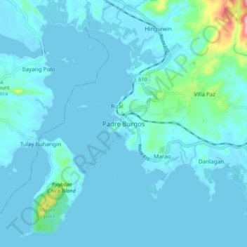
Name: Padre Burgos topographic map, elevation, terrain.
Location: Padre Burgos, Calabarzon, 4303, Philippines (13.87594 121.77495 13.95594 121.85495)
Average elevation: 19 m
Minimum elevation: -1 m
Maximum elevation: 236 m
Make a donation
Gear up for your next adventure:
As an Amazon Associate, this site earns from qualifying purchases at no extra cost to you.