Geolocate

Garding topographic map

Click on the map to display elevation.

About this map
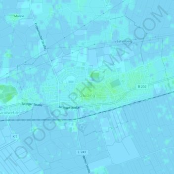
Name: Garding topographic map, elevation, terrain.

Location: Garding, Eiderstedt, Northern Friesland, Schleswig-Holstein, 25836, Germany (54.32319 8.76068 54.33847 8.80191)

Average elevation: 0 m

Minimum elevation: -3 m

Maximum elevation: 5 m

Other topographic maps

Click on a map to view its topography, its elevation and its terrain.
Gear up for your next adventure:

🧦Hiking Socks - Breathable socks designed to prevent blisters on long walks
🗺️Ordnance Survey Maps - Official UK maps for walking and outdoor activities
📢Survival Whistles - Essential safety gear for signaling for help in mountain fog
🛰️Satellite Messengers - Emergency communication devices for areas without mobile signal
🔋Lithium AA Batteries - Long-lasting power that performs well in cold mountain weather

As an Amazon Associate, this site earns from qualifying purchases at no extra cost to you.