
la Vall de Boí topographic map
Interactive map
Click on the map to display elevation.
About this map
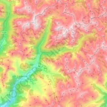
Name: la Vall de Boí topographic map, elevation, terrain.
Location: la Vall de Boí, Alta Ribagorça, Lleida, Catalonia, Spain (42.45411 0.73941 42.63191 0.97266)
Average elevation: 2,141 m
Minimum elevation: 936 m
Maximum elevation: 2,989 m
The small town of Durro is situated at an elevation of 1,386 metres, on a south-facing mountainside. The church has a single long and narrow nave with a barrel vault and slate roof. It was built with a single apse, now replaced by a sacristy. Two square chapels have been built into the northern wall, and the bell tower rises from the northeast corner to five storeys. The entrance is cut into the southern wall, to a covered walkway. The building has been renovated and extended many times since it was built in the 12th century and little of its original appearance remains. The interior retains Baroque features from later renovations.
Other topographic maps
Click on a map to view its topography, its elevation and its terrain.
Vilaller
Spain > Catalonia > Alta Ribagorça
Vilaller, Alta Ribagorça, Lleida, Catalonia, 25552, Spain
Average elevation: 1,845 m