
Make a donation
Gear up for your next adventure:
As an Amazon Associate, this site earns from qualifying purchases at no extra cost to you.
Pachmarhi topographic map
Click on the map to display elevation.
Make a donation
Gear up for your next adventure:
As an Amazon Associate, this site earns from qualifying purchases at no extra cost to you.
Pachmarhi
Pachmarhi has an altitude of 1067. Dhupgarh, the highest point (1,352 meters) in Madhya Pradesh and the Satpura range, is located nearby. The town is wholly located within the Pachmarhi Biosphere Reserve and the Satpura Tiger Reserve.
Make a donation
Gear up for your next adventure:
As an Amazon Associate, this site earns from qualifying purchases at no extra cost to you.
About this map
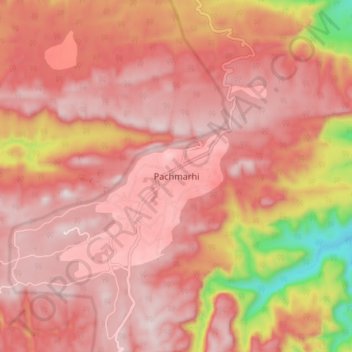
Name: Pachmarhi topographic map, elevation, terrain.
Average elevation: 968 m
Minimum elevation: 522 m
Maximum elevation: 1,144 m
Make a donation
Gear up for your next adventure:
As an Amazon Associate, this site earns from qualifying purchases at no extra cost to you.