
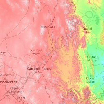
San Luis Potosi topographic map
Interactive map
Click on the map to display elevation.
About this map
Name: San Luis Potosi topographic map, elevation, terrain.
Location: San Luis Potosi, Mexico (21.15969 -102.29604 24.49152 -98.32597)
Average elevation: 1,510 m
Minimum elevation: 11 m
Maximum elevation: 3,382 m
The mean elevation is about 6,000 ft ensuring a temperate climate for the most part. The state lies partly within the arid zone of the north, while the southern half receiving more rainfall through the influence of the Nortes, which deliver significant amounts of rain. The rainfall, however, is uncertain at the western and northern regions, and much of the state does not have major rivers. The soil is fertile and in favorable seasons large crops of wheat, maize, beans and cotton are grown on the uplands. In the low tropical valleys, sugar, coffee, tobacco, peppers and fruit are staple products. Livestock is an important industry and hides, tallow and wool are exported. Fine cabinet and construction woods are also made and exported to a limited extent.
Other topographic maps
Click on a map to view its topography, its elevation and its terrain.
Querétaro
Mexico > Querétaro > Municipio de Querétaro
Querétaro, Municipio de Querétaro, Querétaro, Mexico
Average elevation: 1,921 m
Cabo San Lucas
Mexico > Baja California Sur > Los Cabos Municipality
Cabo San Lucas, Los Cabos Municipality, Baja California Sur, 23470, Mexico
Average elevation: 94 m
San Miguel de Allende
Mexico > Guanajuato > San Miguel de Allende
San Miguel de Allende, Guanajuato, Mexico
Average elevation: 1,964 m
Parque Juárez
Mexico > Puebla > Tehuacán > Tehuacán
Parque Juárez, Tehuacán, Puebla, Mexico
Average elevation: 1,628 m
Parque Juarez
Mexico > Veracruz > Santiago Tuxtla > La Cuchilla
Parque Juarez, La Cuchilla, Santiago Tuxtla, Veracruz, Mexico
Average elevation: 216 m
Cancún
Mexico > Quintana Roo > Benito Juárez
Cancún, Benito Juárez, Quintana Roo, Mexico
Average elevation: 5 m
Corales
Mexico > Guerrero > Técpan de Galeana
Corales, Técpan de Galeana, Guerrero, Mexico
Average elevation: 491 m
San Felipe Zapotitlán
Mexico > Oaxaca > Villa Sola de Vega
San Felipe Zapotitlán, Villa Sola de Vega, Oaxaca, Mexico
Average elevation: 1,763 m
Amatenango del Valle
Mexico > Chiapas > Amatenango del Valle
Amatenango del Valle, Chiapas, Mexico
Average elevation: 1,976 m
Colotitlán
Mexico > Jalisco > Tenamaxtlán
Colotitlán, Tenamaxtlán, Región Sierra de Amula, Jalisco, 48592, Mexico
Average elevation: 1,412 m
Bosques de las Lomas
Mexico > State of Mexico > Ciudad Satélite
Bosques de las Lomas, Miguel Hidalgo, Ciudad Satélite, Mexico City, State of Mexico, 11910, Mexico
Average elevation: 2,414 m
Lázaro Cárdenas
Mexico > State of Mexico > Naucalpan de Juárez
Lázaro Cárdenas, Naucalpan de Juárez, State of Mexico, 53569, Mexico
Average elevation: 2,282 m
Tlajomulco de Zúñiga
Tlajomulco de Zúñiga, Región Centro, Jalisco, Mexico
Average elevation: 1,670 m
San Antonio la Isla
San Antonio la Isla, State of Mexico, Mexico
Average elevation: 2,585 m
San Cristóbal
Mexico > Chiapas > San Cristóbal de las Casas
San Cristóbal, San Cristóbal de las Casas, Chiapas, 29200, Mexico
Average elevation: 2,038 m
Cedros Island
Mexico > Baja California > Municipio de Ensenada
Cedros Island, Municipio de Ensenada, Baja California, 22990, Mexico
Average elevation: 67 m
Yucatán Peninsula
Mexico > Quintana Roo > Othón P. Blanco
Yucatán Peninsula, Othón P. Blanco, Quintana Roo, Mexico
Average elevation: 100 m
Guadalajara
Mexico > Jalisco > Guadalajara
Guadalajara, Jalisco, 44360, Mexico
Average elevation: 1,572 m
Malinche
Mexico > Tlaxcala > Teolocholco
Malinche, Teolocholco, Tlaxcala, Mexico
Average elevation: 3,911 m
Tepeji del Río de Ocampo
Tepeji del Río de Ocampo, Hidalgo, Mexico
Average elevation: 2,296 m
San Juan Colorado
Mexico > Oaxaca > San Juan Colorado
San Juan Colorado, Oaxaca, 71750, Mexico
Average elevation: 412 m
San Miguel
Mexico > Nuevo León > García
San Miguel, García, Nuevo León, Mexico
Average elevation: 1,431 m
Jesús del Monte
Jesús del Monte, Morelia, Michoacán, 58350, Mexico
Average elevation: 2,136 m