Geolocate

Colasi topographic map

Click on the map to display elevation.

About this map

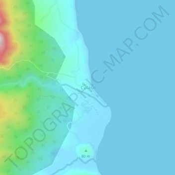
Name: Colasi topographic map, elevation, terrain.

Location: Colasi, Camarines Norte, Bicol Region, Philippines (13.90180 123.06698 13.94180 123.10698)

Average elevation: 59 m

Minimum elevation: -2 m

Maximum elevation: 490 m

Other topographic maps

Click on a map to view its topography, its elevation and its terrain.

Bagasbas Beach

Philippines > Camarines Norte > Daet > Bagasbas

Average elevation: 1 m

Daet

Philippines > Camarines Norte

Average elevation: 6 m

Vinzons

Philippines > Camarines Norte

Average elevation: 10 m

Tailon Island

Philippines > Camarines Norte

Average elevation: 0 m

Gear up for your next adventure:

🔥Reusable Hand Warmers - Maintain dexterity in your fingers for precise map handling
📷Outdoor Action Cameras - Cameras designed for hiking and adventure
🔋Rechargeable Batteries - Eco-friendly power for headlamps and older GPS units
🛌Sleeping Bags - Warm and packable sleeping bags for outdoor nights
👟Heavy Duty Boot Laces - Always carry a spare for your hiking footwear

As an Amazon Associate, this site earns from qualifying purchases at no extra cost to you.