Geolocate

Hollywell topographic map

Click on the map to display elevation.

About this map

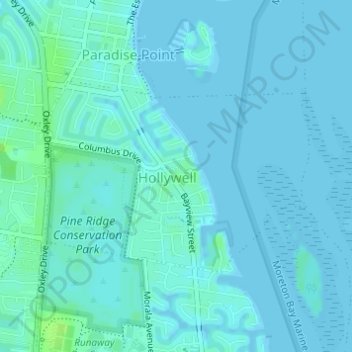
Name: Hollywell topographic map, elevation, terrain.

Location: Hollywell, Gold Coast City, Queensland, Australia (-27.90297 153.38843 -27.88831 153.41143)

Average elevation: 2 m

Minimum elevation: 0 m

Maximum elevation: 11 m

Other topographic maps

Click on a map to view its topography, its elevation and its terrain.

Swan Lake

Australia > Queensland > Gold Coast City

Average elevation: 6 m

Gorge Falls

Australia > Queensland > Gold Coast City

Average elevation: 341 m

Mount Nathan

Australia > Queensland > Gold Coast City

Average elevation: 121 m

Gear up for your next adventure:

🎒Replacement Sternum Straps - Repair parts for hiking rucksacks
📦Compression Sacks - Reduce backpack volume efficiently
🔋Power Banks - Portable chargers for long outdoor trips
🧥Softshell Jackets - Breathable jackets for active outdoor use
🧣Neck Gaiters - Protects against wind and sun on exposed ridges and peaks

As an Amazon Associate, this site earns from qualifying purchases at no extra cost to you.