
Make a donation
Gear up for your next adventure:
As an Amazon Associate, this site earns from qualifying purchases at no extra cost to you.
Zacatecas City topographic map
Click on the map to display elevation.
Make a donation
Gear up for your next adventure:
As an Amazon Associate, this site earns from qualifying purchases at no extra cost to you.
Zacatecas City
The municipality is wedged between the Sierra Madre Occidental and the subrange called Sierras y Valles Zacatecanos. The area is very rugged terrain filled with narrow valleys, ravines and mountains. The principal elevations include Cerro El Grillo at 2,690 m (8,830 ft), Cerro Los Alamitos at 2,680 m (8,790 ft), Cerro La Bufa at 2,650 m (8,690 ft), Cerro La Mesa at 2,590 m (8,500 ft), Mesas El Rincón Colorado at 2,540 m (8,330 ft), Cerro La Mesa at 2,440 m (8,010 ft) and Cerro Grande at 2,370 m (7,780 ft). The area is divided between the Lerma River and El Salado River basins, with a large number of small streams and arroyos crossing the territory.
Make a donation
Gear up for your next adventure:
As an Amazon Associate, this site earns from qualifying purchases at no extra cost to you.
About this map
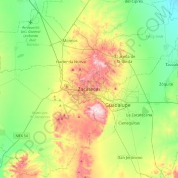
Name: Zacatecas City topographic map, elevation, terrain.
Average elevation: 2,290 m
Minimum elevation: 2,062 m
Maximum elevation: 2,732 m
Make a donation
Gear up for your next adventure:
As an Amazon Associate, this site earns from qualifying purchases at no extra cost to you.