
Yopal topographic map
Interactive map
Click on the map to display elevation.
About this map
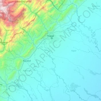
Name: Yopal topographic map, elevation, terrain.
Location: Yopal, Casanare, Colombia (4.90335 -72.58279 5.57104 -71.93888)
Average elevation: 528 m
Minimum elevation: 171 m
Maximum elevation: 3,556 m
Other topographic maps
Click on a map to view its topography, its elevation and its terrain.
Santa Barabara
Santa Barabara, Trinidad, Casanare, Colombia
Average elevation: 142 m
San Francisco
San Francisco, Recetor, Casanare, Colombia
Average elevation: 1,463 m
Puerto Gaitan
Colombia > Casanare > Hato Corozal
Puerto Gaitan, Hato Corozal, Casanare, Colombia
Average elevation: 163 m