
Thank you for supporting this site ❤️
Make a donation
Make a donation
Gear up for your next adventure:
As an Amazon Associate, this site earns from qualifying purchases at no extra cost to you.
Hoy topographic map
Click on the map to display elevation.
Thank you for supporting this site ❤️
Make a donation
Make a donation
Gear up for your next adventure:
As an Amazon Associate, this site earns from qualifying purchases at no extra cost to you.
About this map
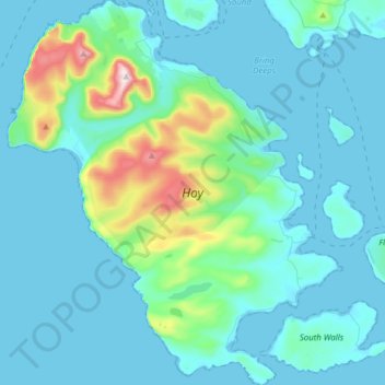
Name: Hoy topographic map, elevation, terrain.
Location: Hoy, Rackwick, Orkney Islands, Scotland, United Kingdom (58.77180 -3.43587 58.93229 -3.16937)
Average elevation: 58 m
Minimum elevation: 0 m
Maximum elevation: 478 m
Orkney Islands trails, hiking, mountain biking, running and outdoor activities
Thank you for supporting this site ❤️
Make a donation
Make a donation
Gear up for your next adventure:
As an Amazon Associate, this site earns from qualifying purchases at no extra cost to you.