
Walenstadt topographic map
Interactive map
Click on the map to display elevation.
About this map
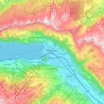
Name: Walenstadt topographic map, elevation, terrain.
Location: Walenstadt, Wahlkreis Sarganserland, St. Gallen, Switzerland (47.08758 9.23815 47.15479 9.40934)
Average elevation: 1,213 m
Minimum elevation: 417 m
Maximum elevation: 2,353 m
Other topographic maps
Click on a map to view its topography, its elevation and its terrain.
Walensee
Switzerland > St. Gallen > Wahlkreis Sarganserland > Quarten
Walensee, Quarten, Wahlkreis Sarganserland, St. Gallen, Switzerland
Average elevation: 1,218 m
Quarten
Switzerland > St. Gallen > Wahlkreis Sarganserland > Quarten
Quarten, Wahlkreis Sarganserland, St. Gallen, Switzerland
Average elevation: 1,283 m
Mels
Switzerland > St. Gallen > Wahlkreis Sarganserland
Mels, Wahlkreis Sarganserland, St. Gallen, Switzerland
Average elevation: 1,317 m
Flums
Switzerland > St. Gallen > Wahlkreis Sarganserland
Flums, Wahlkreis Sarganserland, St. Gallen, Switzerland
Average elevation: 1,328 m