
Make a donation
Gear up for your next adventure:
As an Amazon Associate, this site earns from qualifying purchases at no extra cost to you.
Peru topographic map
Click on the map to display elevation.
Make a donation
Gear up for your next adventure:
As an Amazon Associate, this site earns from qualifying purchases at no extra cost to you.
Peru
Peru has the highest mean altitude in Massachusetts and, along with neighboring Windsor, is one of only two municipalities in the state with a mean elevation above 2,000 feet. It lies on high ground in the Berkshire Hills, with three main peaks in the town. Much of Peru is forested, with a large portion of the northern third of town covered by a wildlife management area, and much of the southern third covered by the Peru and Middlefield State Forests. To the west of town, Ashmere Lake flows out into Bennett Brook, eventually reaching the East Branch of the Housatonic River. To the east, many brooks, including Trout Brook, flow south and east towards the Westfield River, part of the Connecticut River watershed (Trout Brook is actually one of the main sources of the river).
Make a donation
Gear up for your next adventure:
As an Amazon Associate, this site earns from qualifying purchases at no extra cost to you.
About this map
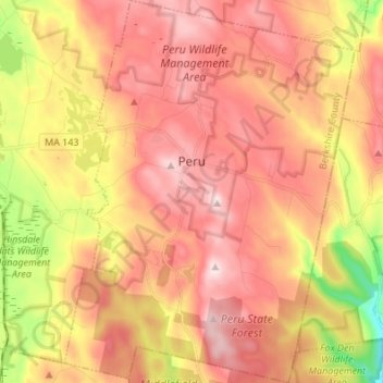
Name: Peru topographic map, elevation, terrain.
Location: Peru, Berkshire County, Massachusetts, 01223, United States (42.37968 -73.09143 42.48012 -72.98813)
Average elevation: 528 m
Minimum elevation: 303 m
Maximum elevation: 677 m
Make a donation
Gear up for your next adventure:
As an Amazon Associate, this site earns from qualifying purchases at no extra cost to you.
Other topographic maps
Click on a map to view its topography, its elevation and its terrain.
Mount Everett
United States > Massachusetts > Berkshire County
Mount Everett helps divide the watersheds of the Hudson and Housatonic rivers. Its eastern slopes share a larger escarpment with Mount Race and Bear Mountain plus several related summits. This escarpment rises from an elevation around 700 feet in Sheffield's Housatonic Valley at a mean angle of about 20…
Average elevation: 561 m
Hephzibah Heights
United States > Massachusetts > Berkshire County > Monterey
Average elevation: 457 m
Mount Greylock
United States > Massachusetts > Berkshire County > Adams
Geographically, Mount Greylock is part of an 11-mile-long (18 km) by 4+1⁄2-mile-wide (7 km) island-like range that runs north-south between the Hoosac Range to the east, the Green Mountains to the north, the Berkshires to both the south and east, and the Taconic Mountains to the west with which it is…
Average elevation: 746 m
Make a donation
Gear up for your next adventure:
As an Amazon Associate, this site earns from qualifying purchases at no extra cost to you.
Southfield
United States > Massachusetts > Berkshire County > New Marlborough
Average elevation: 405 m
Berkshire Heights
United States > Massachusetts > Berkshire County > Great Barrington
Average elevation: 243 m
Make a donation
Gear up for your next adventure:
As an Amazon Associate, this site earns from qualifying purchases at no extra cost to you.
Pittsfield
United States > Massachusetts > Berkshire County
Pittsfield has a humid continental climate (Dfb). Winters are harsh due the city's high elevation at 1,039 ft (317 m), with an average annual snowfall of 75.9 inches (1,930 mm) and temperatures dipping to 0 °F (−18 °C) or colder 13 times per year. Summers, however, are typically warm and pleasant, with…
Average elevation: 433 m
Mount Greylock
United States > Massachusetts > Berkshire County > Adams
Northern hardwood forest characterize lower and mid-elevations, while upper slopes are covered with balsam fir and red spruce as well as American mountain ash. About 555 acres (225 hectares) of old growth forest have been inventoried within the Greylock Range, including tree specimens up to 350 years old. On…
Average elevation: 746 m
Yankee Orchards
United States > Massachusetts > Berkshire County > Pittsfield
Average elevation: 344 m
Make a donation
Gear up for your next adventure:
As an Amazon Associate, this site earns from qualifying purchases at no extra cost to you.
Brookside
United States > Massachusetts > Berkshire County > Great Barrington
Average elevation: 284 m
State Line
United States > Massachusetts > Berkshire County > West Stockbridge
Average elevation: 344 m
Make a donation
Gear up for your next adventure:
As an Amazon Associate, this site earns from qualifying purchases at no extra cost to you.
Clover Hill Farm Conservation Area
United States > Massachusetts > Berkshire County > Williamstown > Meadowvale
Average elevation: 217 m
Risingdale
United States > Massachusetts > Berkshire County > Great Barrington
Average elevation: 277 m
Make a donation
Gear up for your next adventure:
As an Amazon Associate, this site earns from qualifying purchases at no extra cost to you.
Richmond Pond
United States > Massachusetts > Berkshire County > Richmond > Camp Russell
Average elevation: 353 m
Greylock
United States > Massachusetts > Berkshire County > North Adams > Greylock
Average elevation: 314 m
March Cataract Falls
United States > Massachusetts > Berkshire County > Williamstown
Average elevation: 765 m
Make a donation
Gear up for your next adventure:
As an Amazon Associate, this site earns from qualifying purchases at no extra cost to you.
Mountain Meadow Preserve
United States > Massachusetts > Berkshire County > Williamstown
Average elevation: 267 m
Housatonic
United States > Massachusetts > Berkshire County > Great Barrington
Average elevation: 291 m
Make a donation
Gear up for your next adventure:
As an Amazon Associate, this site earns from qualifying purchases at no extra cost to you.
Mount Frissell
United States > Massachusetts > Berkshire County > Mount Washington
Average elevation: 614 m