
Make a donation
Gear up for your next adventure:
As an Amazon Associate, this site earns from qualifying purchases at no extra cost to you.
Waterbury topographic map
Click on the map to display elevation.
Make a donation
Gear up for your next adventure:
As an Amazon Associate, this site earns from qualifying purchases at no extra cost to you.
About this map
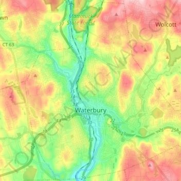
Name: Waterbury topographic map, elevation, terrain.
Average elevation: 167 m
Minimum elevation: 61 m
Maximum elevation: 299 m
Make a donation
Gear up for your next adventure:
As an Amazon Associate, this site earns from qualifying purchases at no extra cost to you.
Other topographic maps
Click on a map to view its topography, its elevation and its terrain.
Huntington
United States > Connecticut > Naugatuck Valley Planning Region > Shelton
Average elevation: 111 m
Minortown
United States > Connecticut > Naugatuck Valley Planning Region > Woodbury
Average elevation: 169 m
White Hills
United States > Connecticut > Naugatuck Valley Planning Region > Shelton
Average elevation: 124 m
Make a donation
Gear up for your next adventure:
As an Amazon Associate, this site earns from qualifying purchases at no extra cost to you.
Mad River
United States > Connecticut > Naugatuck Valley Planning Region > Waterbury > Fair Lawn
Average elevation: 134 m
Traditions
United States > Connecticut > Naugatuck Valley Planning Region > Southbury > South Britain
Average elevation: 112 m
Fox Hollow
United States > Connecticut > Naugatuck Valley Planning Region > Cheshire
Average elevation: 64 m
Westview Heights
United States > Connecticut > Naugatuck Valley Planning Region > Middlebury
Average elevation: 159 m
Make a donation
Gear up for your next adventure:
As an Amazon Associate, this site earns from qualifying purchases at no extra cost to you.
Union City
United States > Connecticut > Naugatuck Valley Planning Region > Naugatuck
Average elevation: 124 m
Warsaw Park
United States > Connecticut > Naugatuck Valley Planning Region > Ansonia
Average elevation: 107 m
Bunker Hill
United States > Connecticut > Naugatuck Valley Planning Region > Waterbury
Average elevation: 140 m
Make a donation
Gear up for your next adventure:
As an Amazon Associate, this site earns from qualifying purchases at no extra cost to you.
Cedar Land
United States > Connecticut > Naugatuck Valley Planning Region > Southbury
Average elevation: 103 m
Town Plot Hill
United States > Connecticut > Naugatuck Valley Planning Region > Waterbury
Average elevation: 127 m
Millville
United States > Connecticut > Naugatuck Valley Planning Region > Naugatuck
Average elevation: 132 m
Bunker Hill
United States > Connecticut > Naugatuck Valley Planning Region > Waterbury
Average elevation: 140 m
Make a donation
Gear up for your next adventure:
As an Amazon Associate, this site earns from qualifying purchases at no extra cost to you.
Bunker Hill
United States > Connecticut > Naugatuck Valley Planning Region > Waterbury
Average elevation: 140 m
Minortown
United States > Connecticut > Naugatuck Valley Planning Region > Woodbury
Average elevation: 169 m
Gulls Hollow
United States > Connecticut > Naugatuck Valley Planning Region > Bethlehem
Average elevation: 243 m
Allentown
United States > Connecticut > Naugatuck Valley Planning Region > Plymouth
Average elevation: 244 m
Make a donation
Gear up for your next adventure:
As an Amazon Associate, this site earns from qualifying purchases at no extra cost to you.