
Make a donation
Gear up for your next adventure:
As an Amazon Associate, this site earns from qualifying purchases at no extra cost to you.
Morón de la Frontera topographic map
Click on the map to display elevation.
Make a donation
Gear up for your next adventure:
As an Amazon Associate, this site earns from qualifying purchases at no extra cost to you.
Morón de la Frontera
In the year 2011 there were 28,489 inhabitants. At that time the municipality was 431.94 km2 (166.77 sq mi), a population density of 65.96 inhabitants/km2, an average altitude of 297 m (974 ft) and is 67 kilometers (42 mi) from the provincial capital, Seville. Morón de la Frontera is ranked 11th in the municipality of the province in terms of the largest population. It is bordered in the north by Marchena and with Arahal. To the east is La Puebla de Cazalla, and to the west and the south are Montellano, Coripe and Pruna along with the province of Cádiz.
Make a donation
Gear up for your next adventure:
As an Amazon Associate, this site earns from qualifying purchases at no extra cost to you.
About this map
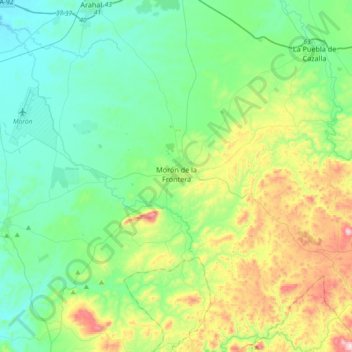
Name: Morón de la Frontera topographic map, elevation, terrain.
Location: Morón de la Frontera, Sevilla, Andalusia, Spain (37.00456 -5.59132 37.23526 -5.22437)
Average elevation: 216 m
Minimum elevation: 59 m
Maximum elevation: 673 m
Make a donation
Gear up for your next adventure:
As an Amazon Associate, this site earns from qualifying purchases at no extra cost to you.
Other topographic maps
Click on a map to view its topography, its elevation and its terrain.
Make a donation
Gear up for your next adventure:
As an Amazon Associate, this site earns from qualifying purchases at no extra cost to you.