
Make a donation
Gear up for your next adventure:
As an Amazon Associate, this site earns from qualifying purchases at no extra cost to you.
Randolph topographic map
Click on the map to display elevation.
Make a donation
Gear up for your next adventure:
As an Amazon Associate, this site earns from qualifying purchases at no extra cost to you.
About this map
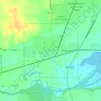
Name: Randolph topographic map, elevation, terrain.
Location: Randolph, Dakota County, Minnesota, United States (44.51867 -93.03003 44.53322 -93.00970)
Average elevation: 270 m
Minimum elevation: 258 m
Maximum elevation: 289 m
Make a donation
Gear up for your next adventure:
As an Amazon Associate, this site earns from qualifying purchases at no extra cost to you.
Other topographic maps
Click on a map to view its topography, its elevation and its terrain.
Burnsville
United States > Minnesota > Dakota County > Burnsville > Burnsville
Average elevation: 275 m
Make a donation
Gear up for your next adventure:
As an Amazon Associate, this site earns from qualifying purchases at no extra cost to you.
Farmington
United States > Minnesota > Dakota County > Farmington > Farmington
Average elevation: 280 m
Make a donation
Gear up for your next adventure:
As an Amazon Associate, this site earns from qualifying purchases at no extra cost to you.