
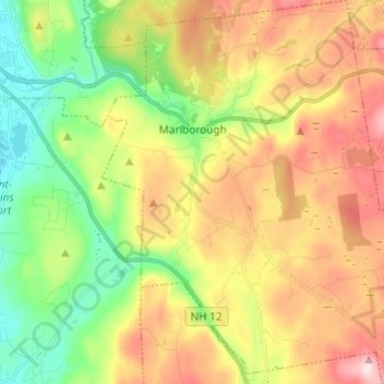
Marlborough topographic map
Interactive map
Click on the map to display elevation.
About this map
Name: Marlborough topographic map, elevation, terrain.
Average elevation: 299 m
Minimum elevation: 135 m
Maximum elevation: 509 m
According to the United States Census Bureau, the town has a total area of 20.7 square miles (53.5 km2), of which 20.4 square miles (52.9 km2) are land and 0.2 square miles (0.6 km2) are water, comprising 1.13% of the town. Marlborough is drained by Minnewawa Brook, a west-flowing tributary of the Ashuelot River and part of the Connecticut River watershed. The town's highest point is near its southeast corner, on the side of Bigelow Hill, where the elevation reaches 1,516 feet (462 m) above sea level.
Other topographic maps
Click on a map to view its topography, its elevation and its terrain.
Stoddard
United States > New Hampshire > Cheshire County
Stoddard, Cheshire County, New Hampshire, United States
Average elevation: 451 m
Chesterfield
United States > New Hampshire > Cheshire County
Chesterfield, Cheshire County, New Hampshire, United States
Average elevation: 229 m
Harrisville
United States > New Hampshire > Cheshire County
Harrisville, Cheshire County, New Hampshire, 03450, United States
Average elevation: 422 m
Gilboa Mountain
United States > New Hampshire > Cheshire County > Westmoreland
Gilboa Mountain, Westmoreland, Cheshire County, New Hampshire, 03467, United States
Average elevation: 331 m
Westmoreland
United States > New Hampshire > Cheshire County
Westmoreland, Cheshire County, New Hampshire, 03467, United States
Average elevation: 228 m
Alstead
United States > New Hampshire > Cheshire County
Alstead, Cheshire County, New Hampshire, United States
Average elevation: 289 m
West Chesterfield
United States > New Hampshire > Cheshire County > Chesterfield
West Chesterfield, Chesterfield, Cheshire County, New Hampshire, 03466, United States
Average elevation: 168 m
Rindge
United States > New Hampshire > Cheshire County
Rindge, Cheshire County, New Hampshire, United States
Average elevation: 343 m
Winchester
United States > New Hampshire > Cheshire County > Winchester
Winchester, Cheshire County, New Hampshire, United States
Average elevation: 167 m
Pisgah State Park
United States > New Hampshire > Cheshire County > Winchester
Pisgah State Park, Winchester, Cheshire County, New Hampshire, United States
Average elevation: 250 m
Keene
United States > New Hampshire > Cheshire County
Keene, Cheshire County, New Hampshire, United States
Average elevation: 263 m
Harper Acres
United States > New Hampshire > Cheshire County > Keene
Harper Acres, Keene, Cheshire County, New Hampshire, 03431, United States
Average elevation: 156 m
Fitzwilliam
United States > New Hampshire > Cheshire County
Fitzwilliam, Cheshire County, New Hampshire, 03447, United States
Average elevation: 345 m
Jaffrey
United States > New Hampshire > Cheshire County
Jaffrey, Cheshire County, New Hampshire, 03452, United States
Average elevation: 351 m
Monte Rosa
United States > New Hampshire > Cheshire County > Jaffrey
Monte Rosa, Jaffrey, Cheshire County, New Hampshire, United States
Average elevation: 634 m