
Smarhon topographic map
Interactive map
Click on the map to display elevation.
About this map
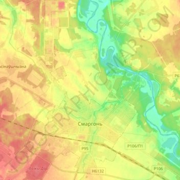
Name: Smarhon topographic map, elevation, terrain.
Location: Smarhon, Smarhon' District, Hrodna Region, Belarus (54.45330 26.34563 54.54418 26.44226)
Average elevation: 156 m
Minimum elevation: 127 m
Maximum elevation: 180 m
Other topographic maps
Click on a map to view its topography, its elevation and its terrain.
Таншчына
Belarus > Hrodna Region > Smarhon' District > Сінькоўскі сельскі Савет
Таншчына, Сінькоўскі сельскі Савет, Smarhon' District, Hrodna Region, Belarus
Average elevation: 289 m