
Colne topographic map
Interactive map
Click on the map to display elevation.
About this map
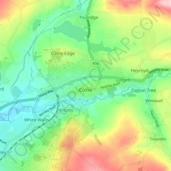
Name: Colne topographic map, elevation, terrain.
Location: Colne, Borough of Pendle, Lancashire, England, United Kingdom (53.84131 -2.20491 53.87446 -2.12707)
Average elevation: 197 m
Minimum elevation: 122 m
Maximum elevation: 328 m
Pendle Leisure Trust runs the Pendle Leisure Centre next to the railway station. The facility has two swimming pools, a fitness centre and gymnasium, sauna and sports hall. In summer 2013, the outdoor all-weather pitch was replaced by Urban Altitude. This outdoor aerial assault course is the first of its kind to be built in the UK in an urban location. It includes high and low rope courses, up to 42 ft off the ground, a 60m Zip-Wire, Leap of Faith, Power Fan Free-fall, Jacobs Ladder and Climbing Wall.
Other topographic maps
Click on a map to view its topography, its elevation and its terrain.
Catlow
United Kingdom > England > Lancashire > Borough of Pendle > Nelson
Catlow, Nelson, Borough of Pendle, Lancashire, England, BB10 3RL, United Kingdom
Average elevation: 243 m
Fence
United Kingdom > England > Lancashire > Borough of Pendle
Fence, Borough of Pendle, Lancashire, England, BB12 9EE, United Kingdom
Average elevation: 187 m
Higham
United Kingdom > England > Lancashire > Borough of Pendle
Higham, Borough of Pendle, Lancashire, England, BB12 9HQ, United Kingdom
Average elevation: 183 m
Laneshaw Bridge
United Kingdom > England > Lancashire > Borough of Pendle
Laneshaw Bridge, Borough of Pendle, Lancashire, England, BB8 7ND, United Kingdom
Average elevation: 239 m
Weets Hill
United Kingdom > England > Lancashire > Borough of Pendle
Weets Hill, Borough of Pendle, Lancashire, England, BB18 5SD, United Kingdom
Average elevation: 300 m
Pendle Hill
United Kingdom > England > Lancashire > Borough of Pendle
Pendle Hill, Borough of Pendle, Lancashire, England, BB9 6LQ, United Kingdom
Average elevation: 385 m
Barrowford
United Kingdom > England > Lancashire > Borough of Pendle
Barrowford, Borough of Pendle, Lancashire, England, United Kingdom
Average elevation: 161 m
Brierfield
United Kingdom > England > Lancashire > Borough of Pendle > Brierfield
Brierfield, Borough of Pendle, Lancashire, England, United Kingdom
Average elevation: 170 m
Nelson
United Kingdom > England > Lancashire > Borough of Pendle
Nelson, Borough of Pendle, Lancashire, England, United Kingdom
Average elevation: 185 m
Barnoldswick
United Kingdom > England > Lancashire > Borough of Pendle
Barnoldswick, Borough of Pendle, Lancashire, England, United Kingdom
Average elevation: 175 m
Earby
United Kingdom > England > Lancashire > Borough of Pendle
Earby, Borough of Pendle, Lancashire, England, United Kingdom
Average elevation: 197 m
Barley
United Kingdom > England > Lancashire > Borough of Pendle
Barley, Borough of Pendle, Lancashire, England, BB12 9JX, United Kingdom
Average elevation: 293 m
Foulridge
United Kingdom > England > Lancashire > Borough of Pendle
Foulridge, Borough of Pendle, Lancashire, England, United Kingdom
Average elevation: 207 m
Salterforth
United Kingdom > England > Lancashire > Borough of Pendle
Salterforth, Borough of Pendle, Lancashire, England, BB18 5TJ, United Kingdom
Average elevation: 190 m
Roughlee
United Kingdom > England > Lancashire > Borough of Pendle
Roughlee, Borough of Pendle, Lancashire, England, BB9 6NS, United Kingdom
Average elevation: 214 m