Gotha topographic map
Click on the map to display elevation.
Gotha
Gotha is situated in a flat landscape within the fertile Thuringian Basin. A tectonic dislocation traverses the city from north-west to south-east. Thereby, it forms three prominent hills: the 431 m high Krahnberg with the Ratsholz forest in the north-west, the hill of Friedenstein Castle in the city centre and the 409 m high Seeberg in the south-east. The city itself lies at an elevation of 300 m and the municipal territory is nearly free of forest (with the two named mountains as exceptions) and is in intensive agricultural use. As one out of only very few ancient cities in Germany, Gotha is not situated on a river, so that water supply was already a problem in the Middle Ages. For that reason, the Leinakanal was built in the 14th century over a distance of more than 25 kilometres, which was at the time an enormous task. The Leinakanal brings water from Hörsel and Apfelstädt river to Gotha, overcoming the watershed between Elbe (Apfelstädt) and Weser (Gotha). The drain of Leinakanal is the Flutgraben, a tributary of Nesse. The Thuringian Forest is located 15 km (9 mi) south-west of Gotha.
About this map
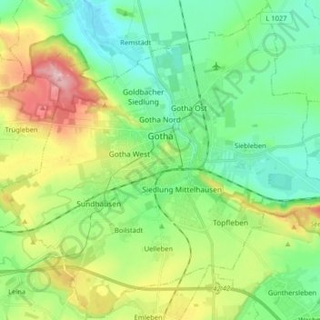
Name: Gotha topographic map, elevation, terrain.
Location: Gotha, Landkreis Gotha, Thuringia, Germany (50.89218 10.62230 50.99128 10.78184)
Average elevation: 320 m
Minimum elevation: 263 m
Maximum elevation: 442 m
Other topographic maps
Click on a map to view its topography, its elevation and its terrain.