
Make a donation
Gear up for your next adventure:
As an Amazon Associate, this site earns from qualifying purchases at no extra cost to you.
Beaver Bank topographic map
Click on the map to display elevation.
Make a donation
Gear up for your next adventure:
As an Amazon Associate, this site earns from qualifying purchases at no extra cost to you.
About this map
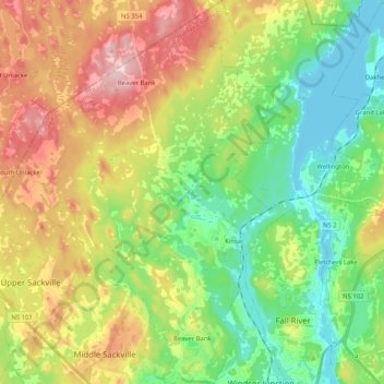
Name: Beaver Bank topographic map, elevation, terrain.
Average elevation: 96 m
Minimum elevation: 13 m
Maximum elevation: 222 m
Make a donation
Gear up for your next adventure:
As an Amazon Associate, this site earns from qualifying purchases at no extra cost to you.
Other topographic maps
Click on a map to view its topography, its elevation and its terrain.
Little Three Cornered Lake
Canada > Nova Scotia > Guysborough District Municipality > Ogden
Average elevation: 120 m
Make a donation
Gear up for your next adventure:
As an Amazon Associate, this site earns from qualifying purchases at no extra cost to you.
South Harbour
Canada > Nova Scotia > Municipality of Victoria County > South Harbour
Average elevation: 22 m
Flat Rock
Canada > Nova Scotia > Municipality of the County of Richmond > Grand River
Average elevation: 5 m
Make a donation
Gear up for your next adventure:
As an Amazon Associate, this site earns from qualifying purchases at no extra cost to you.
Fox Cove North Cape
Canada > Nova Scotia > Municipality of the County of Richmond > Framboise Intervale
Average elevation: 6 m
Make a donation
Gear up for your next adventure:
As an Amazon Associate, this site earns from qualifying purchases at no extra cost to you.
Port Mouton Island
Canada > Nova Scotia > Queens County > South West Port Mouton
Average elevation: 27 m
Wentworth Provincial Park
Canada > Nova Scotia > Municipality of the County of Cumberland > Wentworth Station
Average elevation: 81 m
Carters Beach
Canada > Nova Scotia > Guysborough District Municipality > Hadleyville
Average elevation: 7 m
Make a donation
Gear up for your next adventure:
As an Amazon Associate, this site earns from qualifying purchases at no extra cost to you.
Make a donation
Gear up for your next adventure:
As an Amazon Associate, this site earns from qualifying purchases at no extra cost to you.
Make a donation
Gear up for your next adventure:
As an Amazon Associate, this site earns from qualifying purchases at no extra cost to you.
Margaret Boone Memorial Park
Canada > Nova Scotia > Cape Breton Regional Municipality > Dominion
Average elevation: 13 m
Kidston Island Lighthouse
Canada > Nova Scotia > Municipality of Victoria County > Baddeck
Average elevation: 11 m
Make a donation
Gear up for your next adventure:
As an Amazon Associate, this site earns from qualifying purchases at no extra cost to you.
Mull River
Canada > Nova Scotia > Municipality of the County of Inverness > Mabou
Average elevation: 83 m
Old Fort Point
Canada > Nova Scotia > Municipality of Victoria County > Englishtown
Average elevation: 32 m
Make a donation
Gear up for your next adventure:
As an Amazon Associate, this site earns from qualifying purchases at no extra cost to you.