
Mainland topographic map
Click on the map to display elevation.
About this map
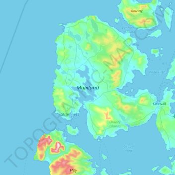
Name: Mainland topographic map, elevation, terrain.
Location: Mainland, Orkney Islands, Scotland, United Kingdom (58.87183 -3.36802 59.15495 -2.70337)
Average elevation: 28 m
Minimum elevation: -1 m
Maximum elevation: 478 m
Orkney Islands trails, hiking, mountain biking, running and outdoor activities
Other topographic maps
Click on a map to view its topography, its elevation and its terrain.
Ward Hill
United Kingdom > Scotland > Orkney Islands
Ward Hill is a hill on the island of Hoy in Orkney, Scotland. It lies at the north of the island between Moaness and Rackwick, and is the highest point in both Orkney and the Scottish Northern Isles at an elevation of 481 m (1,578 ft).
Average elevation: 194 m