Geolocate

Ditchingham topographic map

Click on the map to display elevation.

About this map

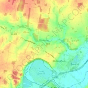
Name: Ditchingham topographic map, elevation, terrain.

Location: Ditchingham, South Norfolk, Norfolk, England, United Kingdom (52.45599 1.40420 52.50293 1.45871)

Average elevation: 23 m

Minimum elevation: 0 m

Maximum elevation: 46 m

Norfolk trails, hiking, mountain biking, running and outdoor activities

Gear up for your next adventure:

🔋Solar Chargers - Eco-friendly charging solutions for outdoor use
🧤Hiking Gloves - Warm and durable gloves for cold-weather walks
📱Phone Mounts for Hiking - Secure mounts to carry your phone on trails
🚲Bikepacking Frame Bags - Storage for tools and navigation gear on long off-road rides
📐Altimeters & Barometers - Tools for measuring altitude and air pressure

As an Amazon Associate, this site earns from qualifying purchases at no extra cost to you.