
Wandlitz topographic map
Interactive map
Click on the map to display elevation.
About this map
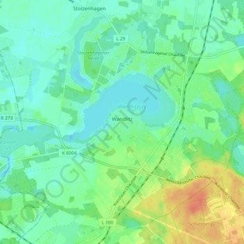
Name: Wandlitz topographic map, elevation, terrain.
Location: Wandlitz, Barnim, Brandenburg, Germany (52.72831 13.40561 52.77746 13.49601)
Average elevation: 57 m
Minimum elevation: 44 m
Maximum elevation: 86 m
Other topographic maps
Click on a map to view its topography, its elevation and its terrain.
Chorin
Germany > Brandenburg > Barnim
Chorin, Britz-Chorin-Oderberg, Barnim, Brandenburg, Germany
Average elevation: 55 m
Ahrensfelde
Germany > Brandenburg > Barnim
Ahrensfelde, Barnim, Brandenburg, 16356, Germany
Average elevation: 67 m
Eberswalde
Germany > Brandenburg > Barnim
Eberswalde, Barnim, Brandenburg, Germany
Average elevation: 53 m
Bernau bei Berlin
Germany > Brandenburg > Barnim > Bernau > Bernau bei Berlin
Bernau bei Berlin, Bernau, Barnim, Brandenburg, 16321, Germany
Average elevation: 77 m
Biesenthal
Germany > Brandenburg > Barnim > Biesenthal-Barnim
Biesenthal, Biesenthal-Barnim, Barnim, Brandenburg, 16359, Germany
Average elevation: 59 m