
Bogota topographic map
Interactive map
Click on the map to display elevation.
Bogota
The city is located in the center of Colombia, on a high plateau known as the Bogotá savanna, part of the Altiplano Cundiboyacense located in the Eastern Cordillera of the Andes. Its altitude averages 2,640 meters (8,660 ft) above sea level. Subdivided into 20 localities, Bogotá has an area of 1,587 square kilometers (613 square miles) and a cool climate that is constant through the year.
About this map
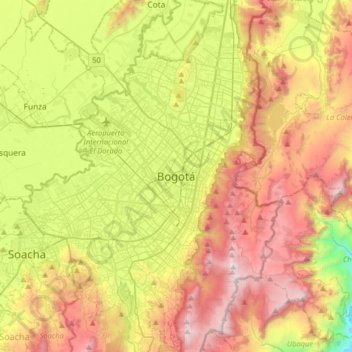
Name: Bogota topographic map, elevation, terrain.
Average elevation: 2,735 m
Minimum elevation: 1,928 m
Maximum elevation: 3,656 m
Other topographic maps
Click on a map to view its topography, its elevation and its terrain.
Villapinzón
Villapinzón is a municipality and town of Colombia in the Almeidas Province, part of the department of Cundinamarca. The urban centre is situated at an elevation of 2,715 metres (8,907 ft) on the Altiplano Cundiboyacense, at a distance of 80 kilometres (50 mi) from the capital Bogotá. Villapinzón borders…
Average elevation: 2,894 m
Boyacá
The department of Boyacá covers a small portion of the Middle Magdalena valley of the Magdalena River to the west, the Cordillera Oriental mountain range with altitudes of 5,380 m above sea level (Sierra Nevada del Cocuy with 25 snow peaks), flat highland plateaux, and another small portion of territory by…
Average elevation: 1,402 m
Villa Cecilia
Colombia > Risaralda > AMCO, Area Metropolitana Centro Occidente
Average elevation: 1,307 m
Bogota
Colombia > Bogota, Capital District
The city is located in the center of Colombia, on a high plateau known as the Bogotá savanna, part of the Altiplano Cundiboyacense located in the Eastern Cordillera of the Andes. Its altitude averages 2,640 meters (8,660 ft) above sea level. Subdivided into 20 localities, Bogotá covers an area of 1,587…
Average elevation: 2,711 m
Villeta
Villeta is a municipality and town in Cundinamarca Department, Colombia. It is located in Gualivá Province, approximately 84 kilometres (52 mi) northwest of Bogotá, considered the capital of the province. Its name means 'little village'. The municipality borders Quebradanegra and Nimaima in the north,…
Average elevation: 1,144 m
Cali
Under Köppen's climate classification, Cali features a dry-summer tropical monsoon climate (Köppen climate classification: Am), bordering a tropical savanna climate (Köppen: As). The Western Mountain Range rises from an average of 2,000 m (6,562 ft) above sea level in the northern part of the city to…
Average elevation: 1,572 m
Cúcuta
The city is in the eastern part of the Department of North Santander, in the Cordillera Oriental, close to the border with Venezuela. The city's area is 110 square kilometres (42 square miles) and its elevation is 320 metres (1,050 feet) above sea level.
Average elevation: 591 m
Comuna 14 - El Poblado
Colombia > Antioquia > Medellín
El Poblado consists of 1,432.58 hectares (3,540.0 acres), encompassing 39% of the Medellín municipality. It is located in the southeastern zone of the city towards the mountains of the Aburrá Valley. The Medellín River borders its western side, separating it from the Guayabal Commune and its elevation east…
Average elevation: 1,732 m
Cesar
Climate in the Department of Cesar presents variations in climate depending on altitude, as well as rainfall precipitations. Mountain climate in the Sierra Nevada de Santa Marta and the Serranía del Perijá become cooler with higher altitude, reaching freezing low temperatures on the snowy peaks. Lowlands…
Average elevation: 413 m
La Guajira
The department was divided into three subregions based on geographical characteristics: Upper, Middle, and Southern Guajira. The Upper Guajira covers the northernmost part of the peninsula, with mostly scarce semi-desertic vegetation. It has only an isolated, low-altitude mountain range, the Serranía de…
Average elevation: 324 m
Floridablanca
Floridablanca (Spanish pronunciation: [floˌɾiðaˈβlaŋka], locally also simply Florida) is a municipality in the department of Santander situated at an altitude of 925 metres (3,035 ft) in the Eastern Ranges of the Colombian Andes. It is part of the metropolitan area of the departmental capital…
Average elevation: 1,260 m
Guadacanal
Colombia > Risaralda > AMCO, Area Metropolitana Centro Occidente
Average elevation: 1,319 m
Cúcuta
The city is in the eastern part of the Department of North Santander, in the Cordillera Oriental, close to the border with Venezuela. The city's area is 110 square kilometres (42 square miles) and its elevation is 320 metres (1,050 feet) above sea level.
Average elevation: 591 m
Santa Fe de Antioquia
The climate of Santa Fe de Antioquia is tropical and humid, typical of Colombia's Cauca River valley, due to its low altitude and its geographical location near the equator. The average temperature is 25.5 °C (77.9 °F) throughout the year. This pleasant weather has allowed tourism to develop in the city,…
Average elevation: 1,630 m
Neiva
Due to its location near the equator and its low altitude, the city has a hot annual average climate with daytime temperatures ranging from 88 to 95 degrees Fahrenheit. It is about 300 kilometers / 186.4 miles (about a five-hour drive) from the Colombian capital, Bogotá.
Average elevation: 1,032 m
La Unión
The locality is part of the Altiplano zone and is located in the highest part of the south of the San Nicolás Valley. The municipality has a complex mountain system, allowing it to have several thermal floors: of its total extension of 198 km², 136 km² comprise a cold climate (including the north, east, and…
Average elevation: 2,410 m
Perímetro Urbano Cúcuta
Colombia > Norte de Santander > Cúcuta
The city is in the eastern part of the Department of North Santander, in the Cordillera Oriental, close to the border with Venezuela. The city's area is 110 square kilometres (42 square miles) and its elevation is 320 metres (1,050 feet) above sea level.
Average elevation: 314 m
Bogota
Colombia > Bogota, Capital District
Bogotá is located in the southeastern part of the Bogotá savanna (Sabana de Bogotá) at an average altitude of 2,640 meters (8,660 ft) above sea level. The Bogotá savanna is popularly called "savannah" (sabana), but constitutes actually a high plateau in the Andes mountains, part of an extended region known…
Average elevation: 2,711 m
Bogota
Colombia > Bogota, Capital District
The city is located in the center of Colombia, on a high plateau known as the Bogotá savanna, part of the Altiplano Cundiboyacense located in the Eastern Cordillera of the Andes. Its altitude averages 2,640 meters (8,660 ft) above sea level. Subdivided into 20 localities, Bogotá covers an area of 1,587…
Average elevation: 2,711 m
Bogota
Colombia > Bogota, Capital District
The city is located in the center of Colombia, on a high plateau known as the Bogotá savanna, part of the Altiplano Cundiboyacense located in the Eastern Cordillera of the Andes. Its altitude averages 2,640 meters (8,660 ft) above sea level. Subdivided into 20 localities, Bogotá covers an area of 1,587…
Average elevation: 2,712 m
Mosquera
Mosquera is a municipality of Colombia in the Western Savanna Province, part of the department of Cundinamarca. Mosquera is close to the capital Bogotá and is part of its metropolitan area. The urban centre of Mosquera is situated at an altitude of 2,516 metres (8,255 ft) on the Bogotá savanna. The…
Average elevation: 2,570 m
Bucaramanga
Bucaramanga is located on a plateau in the Cordillera Oriental of the Colombian Andes, and many residents occupy unstable lands descending steeply from the meseta. Westbound of it, the Rio de Oro Canyon is located at an altitude of 600 metres (2,000 ft) above sea level. Eastbound, the Andean Range rises up in…
Average elevation: 1,269 m
Bogota
Colombia > Bogota, Capital District
The city is located in the center of Colombia, on a high plateau known as the Bogotá savanna, part of the Altiplano Cundiboyacense located in the Eastern Cordillera of the Andes. Its altitude averages 2,640 meters (8,660 ft) above sea level. Subdivided into 20 localities, Bogotá has an area of 1,587 square…
Average elevation: 2,711 m
Cali
Under Köppen's climate classification, Cali features a dry-summer tropical monsoon climate (Köppen climate classification: Am), bordering a tropical savanna climate (Köppen: As). The Western Mountain Range rises from an average of 2,000 m (6,562 ft) above sea level in the northern part of the city to…
Average elevation: 1,284 m
Isla de San Andrés
Colombia > San Andrés and Providencia > La Loma
San Andrés is the largest of the island group in the Department of the Archipelago of San Andrés, Providence and Saint Catherine. San Andrés is located in the Caribbean Sea, about 750 km (470 mi) northwest of the coast of Colombia. The island is 13 km (8.1 mi) in length and 3 km (1.9 mi) in width. It has an…
Average elevation: 3 m