
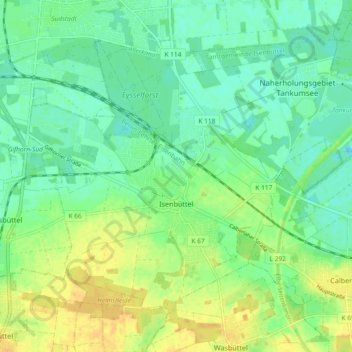
Isenbüttel topographic map
Interactive map
Click on the map to display elevation.
About this map
Name: Isenbüttel topographic map, elevation, terrain.
Average elevation: 61 m
Minimum elevation: 50 m
Maximum elevation: 75 m
Other topographic maps
Click on a map to view its topography, its elevation and its terrain.
Weyhausen
Germany > Lower Saxony > Gifhorn
Weyhausen, Samtgemeinde Boldecker Land, Gifhorn, Lower Saxony, 38554, Germany
Average elevation: 61 m
Ehra
Germany > Lower Saxony > Gifhorn > Ehra-Lessien
Ehra, Ehra-Lessien, Samtgemeinde Brome, Gifhorn, Lower Saxony, 38468, Germany
Average elevation: 75 m