
Thank you for supporting this site ❤️
Make a donation
Make a donation
Gear up for your next adventure:
As an Amazon Associate, this site earns from qualifying purchases at no extra cost to you.
Papaye topographic map
Click on the map to display elevation.
Thank you for supporting this site ❤️
Make a donation
Make a donation
Gear up for your next adventure:
As an Amazon Associate, this site earns from qualifying purchases at no extra cost to you.
About this map
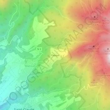
Name: Papaye topographic map, elevation, terrain.
Location: Papaye, Saint-Claude, Basse-Terre, Guadeloupe, 97120, France (16.02520 -61.70642 16.06520 -61.66642)
Average elevation: 783 m
Minimum elevation: 321 m
Maximum elevation: 1,400 m
Thank you for supporting this site ❤️
Make a donation
Make a donation
Gear up for your next adventure:
As an Amazon Associate, this site earns from qualifying purchases at no extra cost to you.