Geolocate

Askole topographic map

Click on the map to display elevation.

About this map

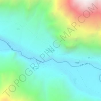
Name: Askole topographic map, elevation, terrain.

Location: Askole, Gulabpur Tehsil, Shigar District, Baltistan Division, Gilgit-Baltistan, Pakistan (35.66194 75.79794 35.70194 75.83794)

Average elevation: 3,360 m

Minimum elevation: 2,885 m

Maximum elevation: 4,730 m

Other topographic maps

Click on a map to view its topography, its elevation and its terrain.

Shigar Tehsil

Pakistan > Gilgit-Baltistan > Shigar District

Average elevation: 4,818 m

Biafo Glacier

Pakistan > Gilgit-Baltistan > Shigar District

Biafo Glacier converging at Hispar La with 49 kilometres (30 mi) long Hispar Glacier situated at an elevation of 5,128 metres (16,824 ft), forms the glacial system considered as the world's longest non-polar glacial system which spans an overall distance of around 120 kilometres (75 mi). This frozen pathway…

Average elevation: 4,618 m

Gear up for your next adventure:

🍱Food Containers - Reusable containers for outdoor meals
🥾Men's Waterproof Hiking Boots - Durable footwear with deep lugs for muddy and rocky UK terrains
🥾Women's Waterproof Hiking Boots - High-performance trekking boots designed for all-weather comfort
🎿Telescopic Trekking Poles - Reduces knee strain on steep topographic descents
👖Hiking Trousers - Durable trousers designed for rough terrain

As an Amazon Associate, this site earns from qualifying purchases at no extra cost to you.