Geolocate

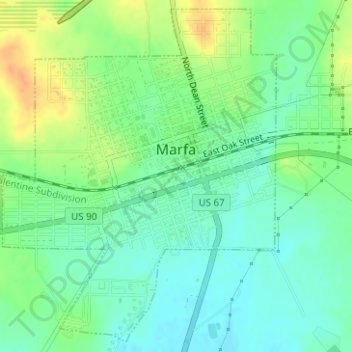
Marfa topographic map

Click on the map to display elevation.

Marfa

Marfa experiences a semi-arid climate (BSk) with hot summers and cool winters. Due to its elevation and aridity, the diurnal temperature variation is substantial.

Wikipedia (CC-BY-SA 3.0)

About this map

Name: Marfa topographic map, elevation, terrain.

Location: Marfa, Presidio County, Texas, 79843, United States (30.29697 -104.03859 30.32254 -104.01421)

Average elevation: 1,434 m

Minimum elevation: 1,420 m

Maximum elevation: 1,456 m

Other topographic maps

Click on a map to view its topography, its elevation and its terrain.
Ruidosa

United States > Texas > Presidio County

Average elevation: 865 m

Cathedral Peak

United States > Texas > Presidio County

Average elevation: 1,375 m

Casa Piedra

United States > Texas > Presidio County

Average elevation: 1,056 m

Shafter

United States > Texas > Presidio County

Average elevation: 1,256 m

Oso Mountain

United States > Texas > Presidio County

Average elevation: 1,354 m

Gear up for your next adventure:

🧢Thermal Beanie Hats - Prevent heat loss from the head in windy summit conditions
🧣Neck Gaiters - Protects against wind and sun on exposed ridges and peaks
🧥Packable Down Jackets - Lightweight warmth that compresses small in your bag
🥼Base Layers - Thermal base layers for temperature regulation
🧼Technical Clothing Wash - Special soap to clean and restore waterproof membranes

As an Amazon Associate, this site earns from qualifying purchases at no extra cost to you.