
Make a donation
Gear up for your next adventure:
As an Amazon Associate, this site earns from qualifying purchases at no extra cost to you.
Gustavia topographic map
Click on the map to display elevation.
Make a donation
Gear up for your next adventure:
As an Amazon Associate, this site earns from qualifying purchases at no extra cost to you.
About this map
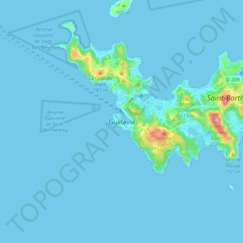
Name: Gustavia topographic map, elevation, terrain.
Location: Gustavia, Saint Barthélemy, 97133, France (17.85570 -62.89084 17.93570 -62.81084)
Average elevation: 14 m
Minimum elevation: 0 m
Maximum elevation: 249 m
Make a donation
Gear up for your next adventure:
As an Amazon Associate, this site earns from qualifying purchases at no extra cost to you.
Other topographic maps
Click on a map to view its topography, its elevation and its terrain.
Saint Barthélemy
Morne de Vitet, 286 metres (938 feet) in height, is the highest peak on the island. Hills and valleys of varying topography cover the rest of the island. Notable are Morne Rouge, Morne Criquet, Morne de Grand Fond, Morne de Dépoudré and Morne Lurin. The largest bodies of water on the island are Étang de…
Average elevation: 4 m
Make a donation
Gear up for your next adventure:
As an Amazon Associate, this site earns from qualifying purchases at no extra cost to you.