Geolocate

Tauranga topographic map

Click on the map to display elevation.

About this map
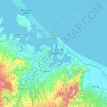
Name: Tauranga topographic map, elevation, terrain.

Location: Tauranga, Tauranga City, Bay of Plenty, 3110, New Zealand (-37.84590 176.00751 -37.52590 176.32751)

Average elevation: 66 m

Minimum elevation: -1 m

Maximum elevation: 548 m

Other topographic maps

Click on a map to view its topography, its elevation and its terrain.
Welcome Bay

New Zealand > Bay of Plenty > Tauranga City

Average elevation: 49 m

Bayfair

New Zealand > Bay of Plenty > Tauranga City

Average elevation: 8 m

Greerton

New Zealand > Bay of Plenty > Tauranga City

Average elevation: 29 m

Tauranga

New Zealand > Bay of Plenty > Tauranga City

Average elevation: 63 m

Gear up for your next adventure:

🔋Power Banks - Portable chargers for long outdoor trips
⛺Camping Shelters - Emergency and lightweight shelters for outdoor use
🍱Food Containers - Reusable containers for outdoor meals
🛌Sleeping Bags - Warm and packable sleeping bags for outdoor nights
📷Camera Straps - Secure straps for carrying cameras while walking

As an Amazon Associate, this site earns from qualifying purchases at no extra cost to you.