Geolocate

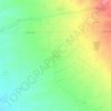
Qushtapa topographic map

Click on the map to display elevation.

About this map

Name: Qushtapa topographic map, elevation, terrain.

Location: Qushtapa, Qoshteppe Subdistrict, Qushtapa District, Erbil Governorate, Iraqi Kurdistan Region, Iraq (35.91328 44.00443 36.04006 44.10387)

Average elevation: 396 m

Minimum elevation: 346 m

Maximum elevation: 493 m

Other topographic maps

Click on a map to view its topography, its elevation and its terrain.
Sardasht

Iraq > Erbil Governorate > Qushtapa District

Average elevation: 461 m

Gear up for your next adventure:

📱Rugged Phone Cases - Heavy-duty protection for smartphones used as secondary GPS tools
🔥Emergency Fire Starters - Reliable ignition tools for survival situations in damp conditions
🔋Lithium AA Batteries - Long-lasting power that performs well in cold mountain weather
🧼Camping Hygiene Kits - Compact hygiene essentials for outdoor stays
🛰️Outdoor GPS Navigation - Navigation devices for remote and off-grid areas

As an Amazon Associate, this site earns from qualifying purchases at no extra cost to you.