Geolocate

Lightwater topographic map

Click on the map to display elevation.

About this map

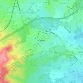
Name: Lightwater topographic map, elevation, terrain.

Location: Lightwater, Windlesham, Surrey Heath, Surrey, England, United Kingdom (51.33902 -0.70422 51.35867 -0.64820)

Average elevation: 62 m

Minimum elevation: 35 m

Maximum elevation: 130 m

Surrey trails, hiking, mountain biking, running and outdoor activities

Other topographic maps

Click on a map to view its topography, its elevation and its terrain.

Camberley

United Kingdom > England > Surrey > Surrey Heath

The Staff College, to the north of Camberley town centre, is part of the Joint Services Command and Staff College, which provides training and education for established officers in the British Armed Forces and civil servants in the Ministry of Defence. The institution has its origins in the Royal Military…

Average elevation: 88 m

Mytchett

United Kingdom > England > Surrey > Surrey Heath

Average elevation: 82 m

Bagshot

United Kingdom > England > Surrey > Surrey Heath

Average elevation: 80 m

Blackdown Hill

United Kingdom > England > Surrey > Surrey Heath

Average elevation: 97 m

Crawley Hill

United Kingdom > England > Surrey > Surrey Heath > Camberley

Average elevation: 91 m

Mimbridge

United Kingdom > England > Surrey > Surrey Heath > Chobham

Average elevation: 26 m

Valley End

United Kingdom > England > Surrey > Surrey Heath

Average elevation: 56 m

Frimley

United Kingdom > England > Surrey > Surrey Heath

Average elevation: 82 m

North Bourne

United Kingdom > England > Surrey > Surrey Heath > Chobham

Average elevation: 33 m

Dunstall Green

United Kingdom > England > Surrey > Surrey Heath > Chobham

Average elevation: 33 m

Frimley Green

United Kingdom > England > Surrey > Surrey Heath

Average elevation: 82 m

Stonehill

United Kingdom > England > Surrey > Surrey Heath

Average elevation: 40 m

Camberley

United Kingdom > England > Surrey > Surrey Heath

The Staff College, to the north of Camberley town centre, is part of the Joint Services Command and Staff College, which provides training and education for established officers in the British Armed Forces and civil servants in the Ministry of Defence. The institution has its origins in the Royal Military…

Average elevation: 88 m

Bagshot

United Kingdom > England > Surrey > Surrey Heath

Average elevation: 80 m

Frimley

United Kingdom > England > Surrey > Surrey Heath

Average elevation: 82 m

Gear up for your next adventure:

📦Dry Bags - Waterproof bags to protect gear from rain
Altimeter Watches - Watches measuring altitude for mountain activities
🧴Tick Removal Tools - Small, essential health tool for UK woodland and moorland
🧤Waterproof Overmitts - Extreme weather protection for hikers and mountaineers
🥤Hydration Bladders - Hands-free hydration systems for backpacks

As an Amazon Associate, this site earns from qualifying purchases at no extra cost to you.