Geolocate

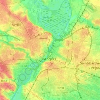
Angers topographic map

Click on the map to display elevation.

Angers

Elevation varies 12 to 64 meters (39 to 210 ft) above sea level.

Wikipedia (CC-BY-SA 3.0)

About this map

Name: Angers topographic map, elevation, terrain.

Location: Angers, Maine-et-Loire, Pays de la Loire, Metropolitan France, France (47.43735 -0.61769 47.52630 -0.50827)

Average elevation: 35 m

Minimum elevation: 5 m

Maximum elevation: 69 m

Other topographic maps

Click on a map to view its topography, its elevation and its terrain.

Cornu

France > Pays de la Loire > Maine-et-Loire > Terranjou

Average elevation: 53 m

Les Pentes

France > Pays de la Loire > Maine-et-Loire > Saumur

Average elevation: 49 m

Conception

France > Pays de la Loire > Maine-et-Loire

Average elevation: 72 m

Gallard

France > Pays de la Loire > Maine-et-Loire > Sèvremoine

Average elevation: 99 m

Gear up for your next adventure:

🔋Solar Chargers - Eco-friendly charging solutions for outdoor use
🔦Head Torches - Hands-free lighting for hiking and camping
📐Altimeters & Barometers - Tools for measuring altitude and air pressure
👟Men's Trail Running Shoes - Lightweight grip for fast movement over topographic contours
🎒Hiking Daypacks (20L) - Compact backpacks for day trips and technical mountain ascents

As an Amazon Associate, this site earns from qualifying purchases at no extra cost to you.