Geolocate

Clane topographic map

Click on the map to display elevation.

About this map

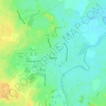
Name: Clane topographic map, elevation, terrain.

Location: Clane, County Kildare, Leinster, Ireland (53.28096 -6.70871 53.30377 -6.67076)

Average elevation: 73 m

Minimum elevation: 62 m

Maximum elevation: 92 m

Other topographic maps

Click on a map to view its topography, its elevation and its terrain.

Allenwood

Ireland > County Kildare

Average elevation: 82 m

Carbury

Ireland > County Kildare

Average elevation: 90 m

Clane

Ireland > County Kildare > Clane

Average elevation: 78 m

Ballyteague Bog

Ireland > County Kildare

Average elevation: 77 m

Rathangan

Ireland > County Kildare > Rathangan

Average elevation: 76 m

Straffan

Ireland > County Kildare > Straffan

Average elevation: 65 m

Gear up for your next adventure:

🧘Folding Sit Mats - Dry and warm seat for map-reading breaks on damp ground
🎒Hiking Daypacks (20L) - Compact backpacks for day trips and technical mountain ascents
🦟Anti-Midge & Tick Repellent - Vital for hiking in the Scottish Highlands during summer
🧤Thermal Touchscreen Gloves - Stay warm while operating your GPS or smartphone camera
Lightweight Solo Tents - Backpacking tents designed for wild camping in the UK highlands

As an Amazon Associate, this site earns from qualifying purchases at no extra cost to you.