
Make a donation
Gear up for your next adventure:
As an Amazon Associate, this site earns from qualifying purchases at no extra cost to you.
eMalahleni topographic map
Click on the map to display elevation.
Make a donation
Gear up for your next adventure:
As an Amazon Associate, this site earns from qualifying purchases at no extra cost to you.
About this map
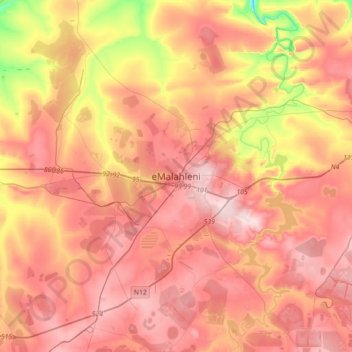
Name: eMalahleni topographic map, elevation, terrain.
Average elevation: 1,520 m
Minimum elevation: 1,332 m
Maximum elevation: 1,644 m
Make a donation
Gear up for your next adventure:
As an Amazon Associate, this site earns from qualifying purchases at no extra cost to you.
Other topographic maps
Click on a map to view its topography, its elevation and its terrain.
Loskop Dam
South Africa > Mpumalanga > Nkangala > Steve Tshwete Local Municipality
Average elevation: 1,211 m
Middelburg Dam
South Africa > Mpumalanga > Nkangala > Steve Tshwete Local Municipality
Average elevation: 1,543 m
Make a donation
Gear up for your next adventure:
As an Amazon Associate, this site earns from qualifying purchases at no extra cost to you.
Steve Tshwete Ward 11
South Africa > Mpumalanga > Nkangala > Steve Tshwete Local Municipality
Average elevation: 1,520 m
Dr JS Moroka Ward 29
South Africa > Mpumalanga > Nkangala > Dr JS Moroka Local Municipality
Average elevation: 1,046 m
Make a donation
Gear up for your next adventure:
As an Amazon Associate, this site earns from qualifying purchases at no extra cost to you.
Rietfontein Dam
South Africa > Mpumalanga > Nkangala > Emalahleni Local Municipality
Average elevation: 1,567 m
Kranspoort Dam
South Africa > Mpumalanga > Nkangala > Steve Tshwete Local Municipality
Average elevation: 1,095 m
Emgwenya (Waterval Boven)
South Africa > Mpumalanga > Nkangala > Emakhazeni Local Municipality
Average elevation: 1,424 m
Make a donation
Gear up for your next adventure:
As an Amazon Associate, this site earns from qualifying purchases at no extra cost to you.
Dr JS Moroka Ward 13
South Africa > Mpumalanga > Nkangala > Dr JS Moroka Local Municipality
Average elevation: 1,037 m
Steve Tshwete Ward 11
South Africa > Mpumalanga > Nkangala > Steve Tshwete Local Municipality
Average elevation: 1,520 m
Make a donation
Gear up for your next adventure:
As an Amazon Associate, this site earns from qualifying purchases at no extra cost to you.
Leratong Stream
South Africa > Mpumalanga > Nkangala > Thembisile Hani Local Municipality > KwaMhlanga
Average elevation: 1,309 m
Make a donation
Gear up for your next adventure:
As an Amazon Associate, this site earns from qualifying purchases at no extra cost to you.
Emakhazeni Local Municipality
South Africa > Mpumalanga > Nkangala > Emakhazeni Local Municipality
Average elevation: 1,579 m