
Kursk Oblast topographic map
Interactive map
Click on the map to display elevation.
Kursk Oblast
The oblast, with an average elevation is 177–225 meters (580–738 ft), occupies the southern slopes of the middle-Russian plateau. The surface is hilly and intersected by ravines. The central part of Kursk oblast is more elevated than the Seym Valley to the west. The Timsko-Shchigrinsky ridge contains the highest point in the oblast at 288 meters (945 ft) above the sea level. The low relief, gentle slopes, and mild winters make the area suitable for farming, and much of the forest has been cleared.
About this map
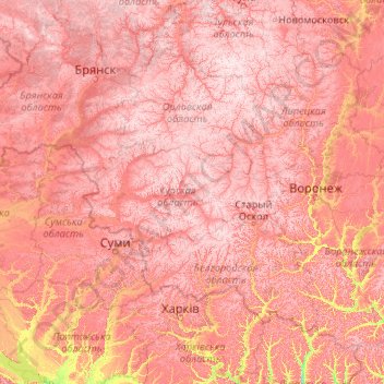
Name: Kursk Oblast topographic map, elevation, terrain.
Location: Kursk Oblast, Central Federal District, Russia (49.09685 33.92527 54.21685 39.04527)
Average elevation: 173 m
Minimum elevation: 54 m
Maximum elevation: 292 m
Other topographic maps
Click on a map to view its topography, its elevation and its terrain.
Kursk
Kursk, located in the Central Federal District of Russia, has a gently rolling topography typical of the Central Russian Upland. Its elevation ranges between 486 and 883 feet (148 to 269 meters) above sea level, with the city itself averaging around 653 feet (199 meters). The terrain is predominantly…
Average elevation: 192 m
городское поселение Дмитриев
Russia > Kursk Oblast > городское поселение Дмитриев
Average elevation: 181 m