
Thank you for supporting this site ❤️
Make a donation
Make a donation
Gear up for your next adventure:
As an Amazon Associate, this site earns from qualifying purchases at no extra cost to you.
Mataduços topographic map
Click on the map to display elevation.
Thank you for supporting this site ❤️
Make a donation
Make a donation
Gear up for your next adventure:
As an Amazon Associate, this site earns from qualifying purchases at no extra cost to you.
About this map
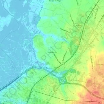
Name: Mataduços topographic map, elevation, terrain.
Location: Mataduços, Esgueira, Aveiro, 3800-027, Portugal (40.64031 -8.64912 40.68031 -8.60912)
Average elevation: 18 m
Minimum elevation: -3 m
Maximum elevation: 52 m
Thank you for supporting this site ❤️
Make a donation
Make a donation
Gear up for your next adventure:
As an Amazon Associate, this site earns from qualifying purchases at no extra cost to you.