
Lake Zurich topographic map
Interactive map
Click on the map to display elevation.
About this map
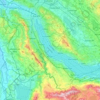
Name: Lake Zurich topographic map, elevation, terrain.
Location: Lake Zurich, Bezirk Meilen, Zurich, Switzerland (47.19131 8.53495 47.36688 8.94793)
Average elevation: 553 m
Minimum elevation: 382 m
Maximum elevation: 1,215 m
Other topographic maps
Click on a map to view its topography, its elevation and its terrain.
Blatten
Switzerland > Zurich > Bezirk Meilen > Männedorf
Blatten, Männedorf, Bezirk Meilen, Zurich, 8708, Switzerland
Average elevation: 471 m
Küsnacht (ZH)
Switzerland > Zurich > Bezirk Meilen
Küsnacht (ZH), Bezirk Meilen, Zurich, 8700, Switzerland
Average elevation: 506 m