
Thank you for supporting this site ❤️
Make a donation
Make a donation
Gear up for your next adventure:
As an Amazon Associate, this site earns from qualifying purchases at no extra cost to you.
Diktaş topographic map
Click on the map to display elevation.
Thank you for supporting this site ❤️
Make a donation
Make a donation
Gear up for your next adventure:
As an Amazon Associate, this site earns from qualifying purchases at no extra cost to you.
About this map
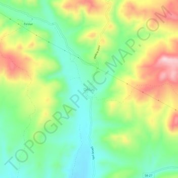
Name: Diktaş topographic map, elevation, terrain.
Location: Diktaş, Divriği, Sivas, Zentralanatolien, Türkei (39.47835 37.86808 39.51835 37.90808)
Average elevation: 1,327 m
Minimum elevation: 1,206 m
Maximum elevation: 1,514 m
Thank you for supporting this site ❤️
Make a donation
Make a donation
Gear up for your next adventure:
As an Amazon Associate, this site earns from qualifying purchases at no extra cost to you.