
Thank you for supporting this site ❤️
Make a donation
Make a donation
Gear up for your next adventure:
As an Amazon Associate, this site earns from qualifying purchases at no extra cost to you.
Westport topographic map
Click on the map to display elevation.
Thank you for supporting this site ❤️
Make a donation
Make a donation
Gear up for your next adventure:
As an Amazon Associate, this site earns from qualifying purchases at no extra cost to you.
About this map
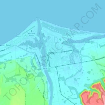
Name: Westport topographic map, elevation, terrain.
Location: Westport, Buller District, West Coast, 7825, New Zealand (-41.79418 171.56357 -41.71418 171.64357)
Average elevation: 13 m
Minimum elevation: -1 m
Maximum elevation: 131 m
Thank you for supporting this site ❤️
Make a donation
Make a donation
Gear up for your next adventure:
As an Amazon Associate, this site earns from qualifying purchases at no extra cost to you.
Other topographic maps
Click on a map to view its topography, its elevation and its terrain.
Buller River Mouth Wildlife Refuge
New Zealand > West Coast > Buller District > Westport
Average elevation: 5 m