Geolocate

Batulao topographic map

Click on the map to display elevation.

About this map

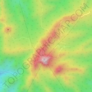
Name: Batulao topographic map, elevation, terrain.

Location: Batulao, Nasugbu, Tuy, Batangas, Calabarzon, Philippines (14.03525 120.79732 14.05342 120.81191)

Average elevation: 531 m

Minimum elevation: 289 m

Maximum elevation: 775 m

Gear up for your next adventure:

🧗Locking Carabiners - Secure gear to your pack or for light technical use
🌂Windproof Trekking Umbrellas - Surprising but effective rain protection on low-wind trails
👖Packable Overtrousers - Quick-deploy rain protection for legs in sudden storms
👕Merino Base Layers - Natural temperature regulation for cold weather hiking and camping
👟Men's Trail Running Shoes - Lightweight grip for fast movement over topographic contours

As an Amazon Associate, this site earns from qualifying purchases at no extra cost to you.