Geolocate

Larapinta topographic map

Click on the map to display elevation.

About this map

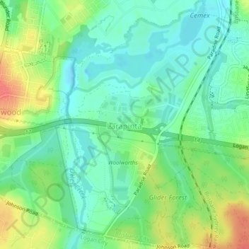
Name: Larapinta topographic map, elevation, terrain.

Location: Larapinta, Brisbane City, Queensland, Australia (-27.65742 152.99676 -27.62388 153.02271)

Average elevation: 32 m

Minimum elevation: 12 m

Maximum elevation: 68 m

Other topographic maps

Click on a map to view its topography, its elevation and its terrain.

Teneriffe

Australia > Queensland > Brisbane City

Average elevation: 11 m

Constitution Hill

Australia > Queensland > Brisbane City

Average elevation: 144 m

Gear up for your next adventure:

❄️Walking Crampons - Added traction for icy slopes and winter peak bagging
🥤Collapsible Water Bottles - Save space in your rucksack as you consume your water
🌦️Portable Weather Meters - Handheld tools for monitoring weather conditions
📦Dry Bags - Waterproof bags to protect gear from rain
🌄Compact Monoculars - Lightweight optics for hiking

As an Amazon Associate, this site earns from qualifying purchases at no extra cost to you.