
Make a donation
Gear up for your next adventure:
As an Amazon Associate, this site earns from qualifying purchases at no extra cost to you.
Bharuch topographic map
Click on the map to display elevation.
Make a donation
Gear up for your next adventure:
As an Amazon Associate, this site earns from qualifying purchases at no extra cost to you.
Bharuch
Bharuch is located at 21°42′N 72°58′E / 21.7°N 72.97°E / 21.7; 72.97. It has an average elevation of 15 metres (49 feet). Bharuch is a port city situated on the banks of the Narmada river. The damming of the Narmada caused the original port facilities to close, the nearest port is now in Dahej. The Bharuch district is surrounded by Vadodara (North), Narmada (East) and Surat (South) districts. To the west is the Gulf of Khambhat.
Make a donation
Gear up for your next adventure:
As an Amazon Associate, this site earns from qualifying purchases at no extra cost to you.
About this map
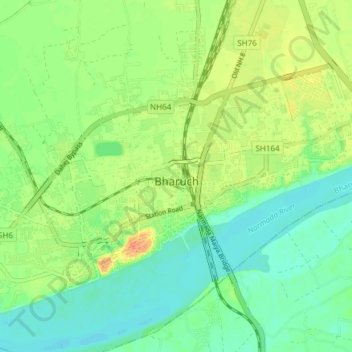
Name: Bharuch topographic map, elevation, terrain.
Location: Bharuch, Bharuch Taluka, Bharuch, Gujarat, India (21.68519 72.96262 21.73299 73.03773)
Average elevation: 15 m
Minimum elevation: 0 m
Maximum elevation: 38 m
Make a donation
Gear up for your next adventure:
As an Amazon Associate, this site earns from qualifying purchases at no extra cost to you.