Geolocate

Heikendorf topographic map

Click on the map to display elevation.

About this map
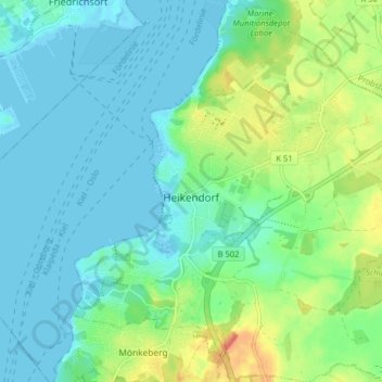
Name: Heikendorf topographic map, elevation, terrain.

Location: Heikendorf, Schrevenborn, Kreis Plön, Schleswig-Holstein, 24226, Germany (54.34671 10.17777 54.39317 10.25394)

Average elevation: 14 m

Minimum elevation: -2 m

Maximum elevation: 53 m

Other topographic maps

Click on a map to view its topography, its elevation and its terrain.
Heidkate

Germany > Schleswig-Holstein > Kreis Plön > Wisch

Average elevation: -1 m

Gear up for your next adventure:

📻Hand-Crank Emergency Radios - Stay updated on weather warnings in remote areas
🥼Base Layers - Thermal base layers for temperature regulation
🎒Hiking Daypacks (20L) - Compact backpacks for day trips and technical mountain ascents
🧤Thermal Touchscreen Gloves - Stay warm while operating your GPS or smartphone camera
🗺️Ordnance Survey Maps - Official UK maps for walking and outdoor activities

As an Amazon Associate, this site earns from qualifying purchases at no extra cost to you.