Geolocate

Frisco topographic map

Click on the map to display elevation.

About this map

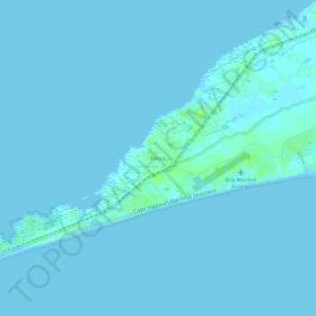
Name: Frisco topographic map, elevation, terrain.

Location: Frisco, Dare County, North Carolina, 27936, United States (35.21518 -75.64849 35.25518 -75.60849)

Average elevation: 1 m

Minimum elevation: 0 m

Maximum elevation: 10 m

Gear up for your next adventure:

Camping Shelters - Emergency and lightweight shelters for outdoor use
🧺Mesh Stuff Sacks - Breathable storage for wet gear or camp organization
🧣Neck Gaiters - Protects against wind and sun on exposed ridges and peaks
📐Altimeters & Barometers - Tools for measuring altitude and air pressure
🐕Dog Hiking Gear - Equipment for hiking safely with dogs

As an Amazon Associate, this site earns from qualifying purchases at no extra cost to you.