
Make a donation
Gear up for your next adventure:
As an Amazon Associate, this site earns from qualifying purchases at no extra cost to you.
Austin topographic map
Click on the map to display elevation.
Make a donation
Gear up for your next adventure:
As an Amazon Associate, this site earns from qualifying purchases at no extra cost to you.
Austin
According to the U.S. Census Bureau, Austin has a total area of 13.39 square miles (34.68 km2), of which 13.29 square miles (34.42 km2) are land and 0.11 square miles (0.28 km2), or 0.79%, are water. Its elevation is approximately 1,200 ft (370 m). The Cedar River, a tributary of the Iowa River, flows southward through the east side of the city. Tributaries within the city include Turtle Creek from the west and Dobbins Creek from the east.
Make a donation
Gear up for your next adventure:
As an Amazon Associate, this site earns from qualifying purchases at no extra cost to you.
About this map
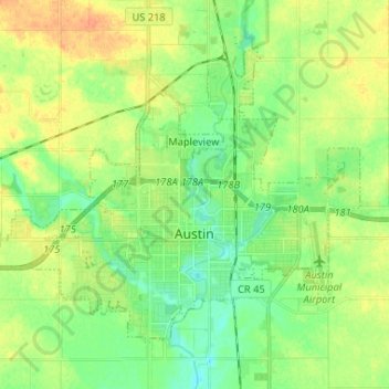
Name: Austin topographic map, elevation, terrain.
Location: Austin, Mower County, Minnesota, 55912, United States (43.64170 -93.04923 43.71334 -92.91901)
Average elevation: 374 m
Minimum elevation: 359 m
Maximum elevation: 393 m
Make a donation
Gear up for your next adventure:
As an Amazon Associate, this site earns from qualifying purchases at no extra cost to you.
Other topographic maps
Click on a map to view its topography, its elevation and its terrain.