
Make a donation
Gear up for your next adventure:
As an Amazon Associate, this site earns from qualifying purchases at no extra cost to you.
Sudova Vyshnia Urban Hromada topographic map
Click on the map to display elevation.
Make a donation
Gear up for your next adventure:
As an Amazon Associate, this site earns from qualifying purchases at no extra cost to you.
About this map
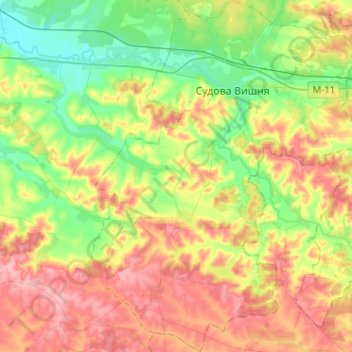
Name: Sudova Vyshnia Urban Hromada topographic map, elevation, terrain.
Average elevation: 257 m
Minimum elevation: 203 m
Maximum elevation: 324 m
Make a donation
Gear up for your next adventure:
As an Amazon Associate, this site earns from qualifying purchases at no extra cost to you.
Other topographic maps
Click on a map to view its topography, its elevation and its terrain.
Make a donation
Gear up for your next adventure:
As an Amazon Associate, this site earns from qualifying purchases at no extra cost to you.
Make a donation
Gear up for your next adventure:
As an Amazon Associate, this site earns from qualifying purchases at no extra cost to you.
Verecke Pass
The pass is located in the Carpathian Mountains just where the oblasts of Lviv and Transcarpathia meet, on the spine of the Northeastern Carpathians, between the Latorica (or Latorytsia) and Opir river valleys and at the river divide or watershed between the Latorytsia and the Stryi. It has an elevation of 841…
Average elevation: 749 m
Make a donation
Gear up for your next adventure:
As an Amazon Associate, this site earns from qualifying purchases at no extra cost to you.
Basivka
The village covers an area of 2,39 km2 at an altitude of 305 metres (1,000 ft) above sea level. The population of village is just about 1042 persons and local government is administered by the Hodovytsko-Basivska village council.
Average elevation: 318 m
Basivka
The village covers an area of 2,39 km2 at an altitude of 305 metres (1,000 ft) above sea level. The population of village is just about 1042 persons and local government is administered by the Hodovytsko-Basivska village council.
Average elevation: 318 m
Make a donation
Gear up for your next adventure:
As an Amazon Associate, this site earns from qualifying purchases at no extra cost to you.
Make a donation
Gear up for your next adventure:
As an Amazon Associate, this site earns from qualifying purchases at no extra cost to you.
Make a donation
Gear up for your next adventure:
As an Amazon Associate, this site earns from qualifying purchases at no extra cost to you.
Make a donation
Gear up for your next adventure:
As an Amazon Associate, this site earns from qualifying purchases at no extra cost to you.
Ландшафтний заказник місцевого значення «Романівський»
Ukraine > Lviv Oblast > Romaniv
Average elevation: 414 m
Make a donation
Gear up for your next adventure:
As an Amazon Associate, this site earns from qualifying purchases at no extra cost to you.
Make a donation
Gear up for your next adventure:
As an Amazon Associate, this site earns from qualifying purchases at no extra cost to you.