

Prijedor topographic map
Click on the map to display elevation.
Prijedor
The urban centre of Prijedor, within the city of Prijedor, is located in the northwestern part of Bosnia and Herzegovina, on the banks of the Sana and Gomjenica rivers, and at the southwestern hills of the Kozara mountain. The area of the municipality is 833 square kilometres (322 square miles). The town is situated at 44°58'39" N and 16°42'29" E, at an altitude of 133 metres (436 feet) above sea level.
About this map
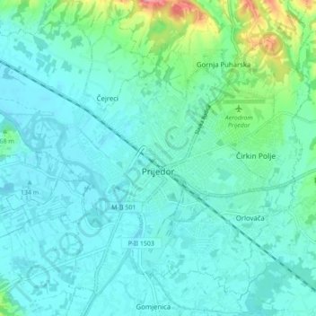
Name: Prijedor topographic map, elevation, terrain.
Average elevation: 147 m
Minimum elevation: 126 m
Maximum elevation: 253 m
Other topographic maps
Click on a map to view its topography, its elevation and its terrain.
Kozarački kamen
Bosnia and Herzegovina > Republika Srpska > City of Prijedor > MZ Kozarac
Average elevation: 449 m