
Make a donation
Gear up for your next adventure:
As an Amazon Associate, this site earns from qualifying purchases at no extra cost to you.
Pemberton topographic map
Click on the map to display elevation.
Make a donation
Gear up for your next adventure:
As an Amazon Associate, this site earns from qualifying purchases at no extra cost to you.
About this map
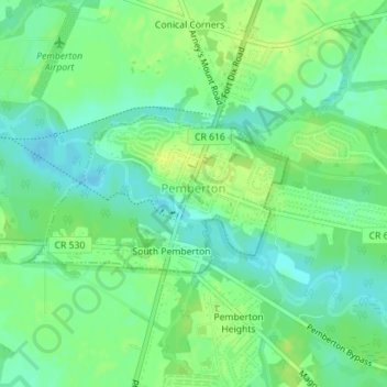
Name: Pemberton topographic map, elevation, terrain.
Location: Pemberton, Burlington County, New Jersey, United States (39.96606 -74.69796 39.97712 -74.67420)
Average elevation: 19 m
Minimum elevation: 10 m
Maximum elevation: 26 m
Make a donation
Gear up for your next adventure:
As an Amazon Associate, this site earns from qualifying purchases at no extra cost to you.
Other topographic maps
Click on a map to view its topography, its elevation and its terrain.
Hampton Gate
United States > New Jersey > Burlington County > Tabernacle Township
Average elevation: 24 m
East Riverton
United States > New Jersey > Burlington County > Cinnaminson Township > Riverton
Average elevation: 9 m
Make a donation
Gear up for your next adventure:
As an Amazon Associate, this site earns from qualifying purchases at no extra cost to you.
Jobstown
United States > New Jersey > Burlington County > Springfield Township
Average elevation: 22 m
Fostertown
United States > New Jersey > Burlington County > Lumberton Township
Average elevation: 14 m
Make a donation
Gear up for your next adventure:
As an Amazon Associate, this site earns from qualifying purchases at no extra cost to you.
Timbuctoo
United States > New Jersey > Burlington County > Westampton Township
Average elevation: 14 m
Marlboro
United States > New Jersey > Burlington County > Evesham Township > Marlton
Average elevation: 26 m
Make a donation
Gear up for your next adventure:
As an Amazon Associate, this site earns from qualifying purchases at no extra cost to you.
Upper Mill
United States > New Jersey > Burlington County > Pemberton Township
Average elevation: 31 m
Stow Acres
United States > New Jersey > Burlington County > Evesham Township > Marlton
Average elevation: 24 m
Make a donation
Gear up for your next adventure:
As an Amazon Associate, this site earns from qualifying purchases at no extra cost to you.
Pine Lane
United States > New Jersey > Burlington County > Springfield Township
Average elevation: 25 m
Riverton
United States > New Jersey > Burlington County > Cinnaminson Township
Average elevation: 12 m
Make a donation
Gear up for your next adventure:
As an Amazon Associate, this site earns from qualifying purchases at no extra cost to you.
Fellowship
United States > New Jersey > Burlington County > Mount Laurel Township
Average elevation: 16 m
Make a donation
Gear up for your next adventure:
As an Amazon Associate, this site earns from qualifying purchases at no extra cost to you.
Make a donation
Gear up for your next adventure:
As an Amazon Associate, this site earns from qualifying purchases at no extra cost to you.